IN FOCUS: Singapore has reduced its flood-prone areas by over 100 times. Is there room for more?
CNA
12 Feb
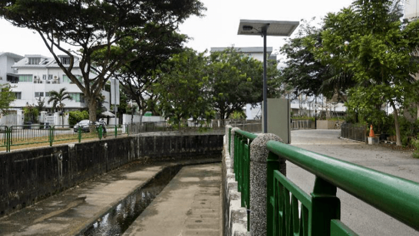
SINGAPORE: Retiree Xu Si Ming still remembers how his childhood home at Margaret Drive used to flood back in 1960s and 70s.
As rain lashed down on Singapore, water pooling on the ground floor would rise to chest levels.
“My mother would page me and I would rush home to move the furniture upstairs," said the 70-year-old in Mandarin. “You’ll have to be careful when you step outside the house because the water would cover the drain and you could fall down."
His family used a makeshift barrier reinforced with plasticine at the front door, but murky flood water would still enter the house via clogged pipes and drains in the toilet.
Those early decades of Singapore’s independence were marked by major floods that ruined farms and caused fatalities. Around 3,200ha of the land then was vulnerable to flooding.
While these areas have shrunk as Singapore moved to beef up its drainage network, heavy rains and the resultant floods still plagued some parts of the island into the 21st century.
Today, less than 25ha of Singapore is prone to flooding.
Mr Xu's old home, for instance, has since made way for one of the tallest public housing flats in Singapore, Skyville at Dawson.
He still stays in the area, in a flat not far from Margaret Drive, and told CNA he hardly sees floods anymore. Mr Xu believes the nearby Alexandra Canal, which has been upgraded over the years, has solved the issue.
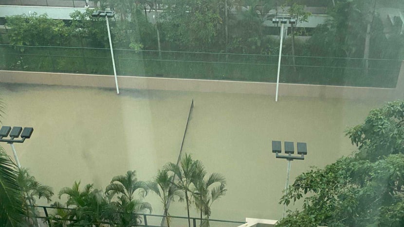
Elsewhere in Singapore, however, flash floods continue to occur during periods of high rainfall.
DRAIN NETWORK
Key to Singapore's battle against floods has been massive investments in drainage works over the years.
Since 2011, the country has spent about S$2.5 billion (US$1.85 billion) upgrading infrastructure and will be injecting another approximately S$150 million for the 2025 financial year.
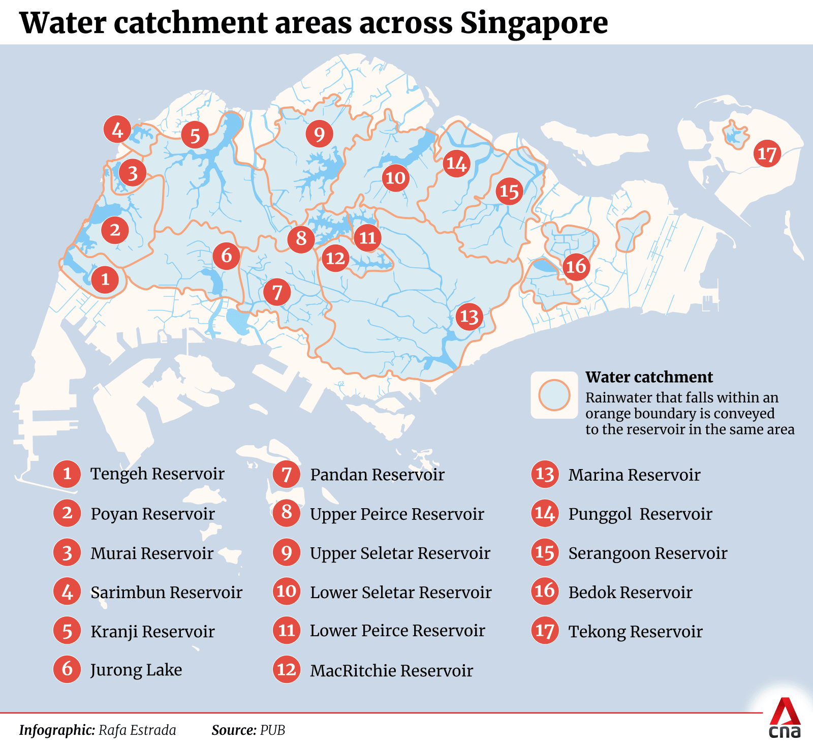
There is now an 8,000km network of interconnected drains, canals and rivers, capturing rainwater landing on two-thirds of the land and conveying it to 16 reservoirs on the mainland.
The remaining one-third of Singapore not served by reservoirs is along its coasts, where rainwater is directed to the sea.
“(The drains) all have a gradient, and a lot of these drains are following the natural topography," Ms Joanne Siew, a senior principal engineer at national water agency PUB, told CNA.
"The drains convey stormwater towards the reservoirs, which then becomes the raw water stock for our water supply treatment."
Parts of this network require the capacity to cope with the volume of rainwater during storms. In 2011, design standards were raised so that drains can handle up to 50 per cent higher rainfall intensities depending on the catchment size.
02:08 Min
National water agency PUB will spend about S$150 million to upgrade drains this year to improve flood resilience. The money will be used to fund 25 projects — including six new ones — that are slated to begin this year. Sustainability and the Environment Minister Grace Fu was responding to a question in Parliament on last month's monsoon surges. Eugene Chow reports.
SPACE CONSTRAINTS
To alleviate flooding, there have also been major projects over time such as Marina Barrage, which Ms Siew said helps in particular low-lying areas like Chinatown.
As Singapore's population grows, however, less land is available for such infrastructure.
Professor Vladan Babovic from the National University of Singapore’s (NUS) civil and environmental engineering department pointed out that there are around 9,000 people per square kilometre here.
“We need land for roads, for buildings, for schools. So widening and increasing drains is just going to be prohibitively expensive and will take useful land space away.”
An expert panel reviewing Singapore’s protection measures in the wake of the 2010 Orchard Road floods also said a wholescale upsizing of the drainage system would be disruptive.
“The whole country will develop (into) something not necessarily nice to live in. Would you like to live in a watertight bunker?” said Prof Babovic.
Associate Professor Tay Zhi Yung of the Singapore Institute of Technology’s (SIT) engineering cluster said that instead of "total flood prevention", the focus should be on risk management to minimise damage and disruption.
“In urban areas, constructing detention tanks, increasing the height of retention walls ... might be more practical solutions," he noted.
"In locations where space allows for innovative approaches, nature-based solutions integrated with engineering methods may be more sustainable than relying solely on infrastructure, such as widening canals and drains.”
Authorities in Singapore recognise that upgrading drains is just one part of the puzzle, said PUB's Ms Siew.
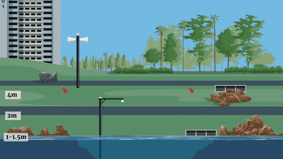
For example, a code of practice dictates the minimum platform levels for buildings and infrastructure.
Buildings in the northern and southern areas require respective platform levels of 4.5m and 4m Singapore height datum, or what used to be referred to as above mean sea level.
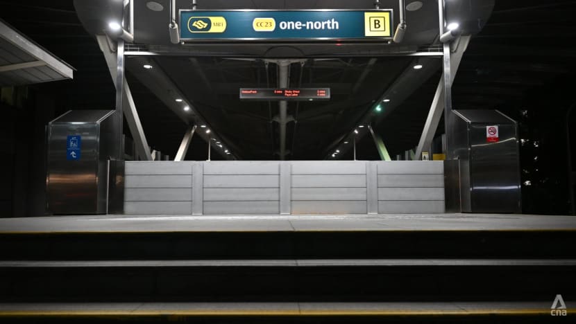
Underground MRT stations also need to have entrances that are 1.3m above adjacent ground. Those that fall short of this requirement are equipped with flood barriers.
Singapore has also looked to underground spaces to manage floods, with two subterranean detention tanks - Stamford Detention Tank under Botanic Gardens and Opera Estate Detention Tank near Bedok - designed to capture rainwater during storms.
The larger Stamford tank, stores up to 38,000 cubic metres of rainwater before pumping it back into drains that flow to Stamford Diversion Canal when storms subside.
This system is the reason why Orchard Road no longer sees severe flooding.
A third underground detention tank is being built beside Syed Alwi Road, to reduce flooding in Jalan Besar.
PUB continues to study the feasibility of a more extensive underground system to combat both inland and coastal flooding.
SO WHY ARE THERE STILL FLOODS?
Experts say it comes down to a combination of factors.
For coastal areas, they flood when rainy weather coincides with a high tide.
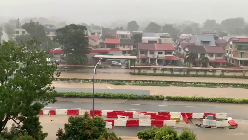
This was the case in Jalan Seaview, which is close to the east coast. The area flooded in January during a monsoon surge which saw higher than average monthly rainfall.
Some parts there remain vulnerable as road levels are only marginally above high tide level.
“If the tidal level is high, stormwater will not be able to flow into the sea, (which) will result in backflow and cause the water level in the canals and drains to rise, which may lead to flash floods,” said Mr David Ng, who chairs the civil and structural engineering technical committee at the Institution of Engineers, Singapore (IES).
In fact, much of Singapore’s coast lies less than 5m above mean sea level, making it susceptible to floods when high tides occur alongside extreme weather events.
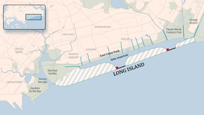
To tackle sea level rise, authorities are conducting studies to assess the measures best-suited to specific sites. This was how the idea of a reclaimed "Long Island" at east coast came about.
For inland areas, flooding can occur due to low elevation combined with a high intensity or long duration of rainfall as well as inadequacy of drainage channels, engineers said.
Ms Siew also cited increased construction or built-up infrastructure as a factor.
Forested environments are able to absorb and filter rainwater through vegetation and soil.
With urbanisation, nature is replaced by hard and impervious surfaces like buildings and roads. As a result, rainwater runs off these surfaces into drains, instead of filtering into the ground. Stormwater runoff could flood the area if not properly channelled, or overwhelm existing channels.
Urban planners thus need to calculate and account for the volume of runoff when an area undergoes development.
Since 2014, new developments or redevelopments in Singapore that are 0.2ha or larger have needed to implement on-site measures like stormwater detention tanks, said Ms Siew.
PUB also keeps a list of 36 flood-prone areas in Singapore. These are low-lying zones with a history of flooding, including Margaret Drive and Stevens Road in Bukit Timah.
A separate list keeps track of hotspots that flood more than twice a year. As of end-2024, this contains 22 locations, including Dunearn Road and a portion of Bukit Timah Road.
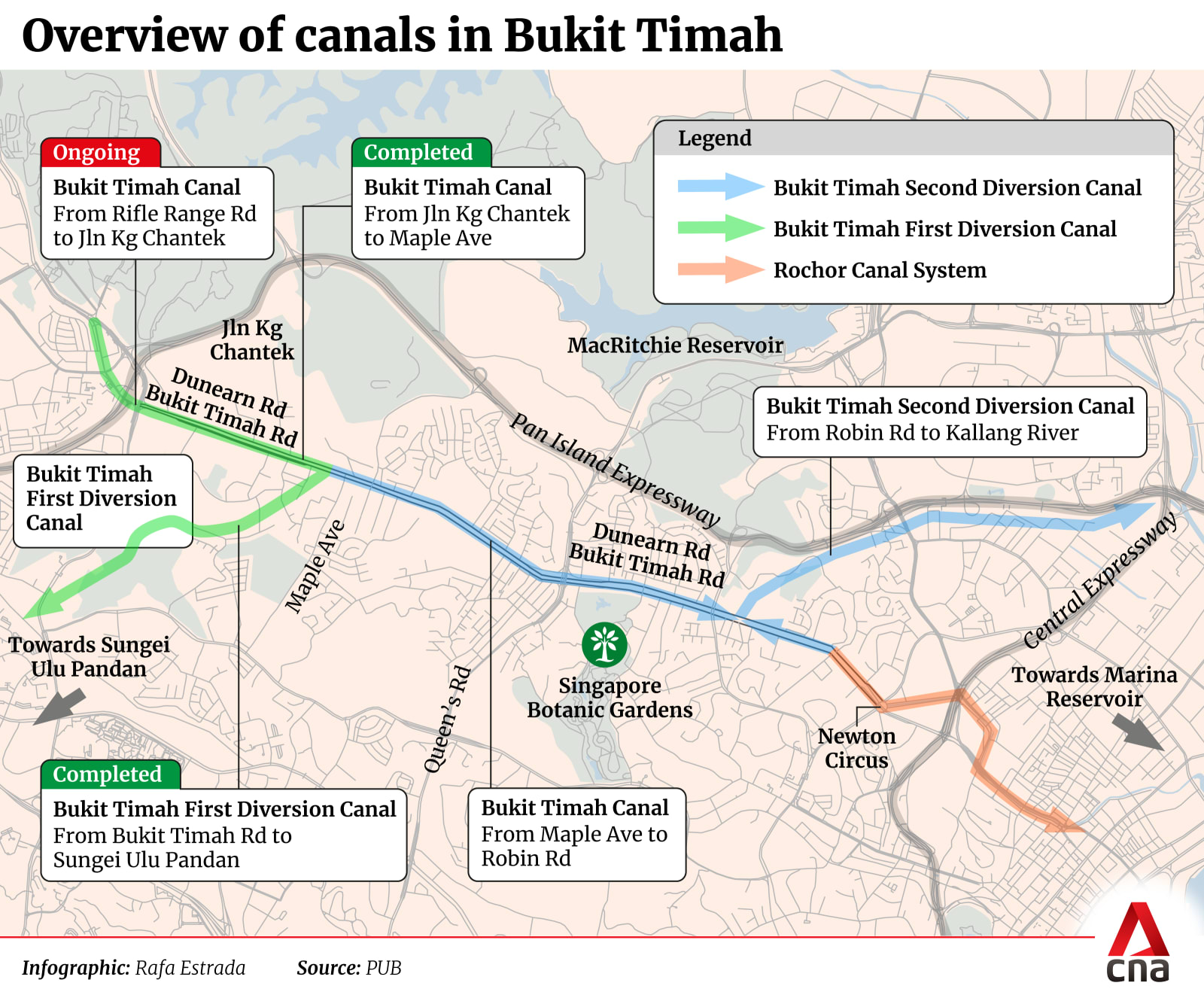
THE BUKIT TIMAH CASE
PUB currently has 19 ongoing drainage upgrading projects, with six more slated to start this year.
One ongoing project is at Bukit Timah, an area well-documented for flooding despite constant upgrades over the years.
The main Bukit Timah Canal runs between Bukit Timah Road and Dunearn Road.
The first diversion canal to help with floods there was built in 1972. It uses a gate to divert water from the main canal to flow to a reservoir. A second diversion canal was completed in 1990, stretching from Robin Road to Kallang River.
The two diversion canals help split a load that would otherwise overwhelm the main canal, and effectively divide the Bukit Timah precinct into three catchment areas.
Upgrading works to the first diversion canal began in 2012 and concluded seven years later to the tune of S$300 million. It can now convey 30 per cent more rainwater than before.
In 2013, a stretch of the main Bukit Timah Canal - from Jalan Kampong Chantek to Maple Avenue - was also expanded.
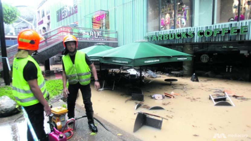
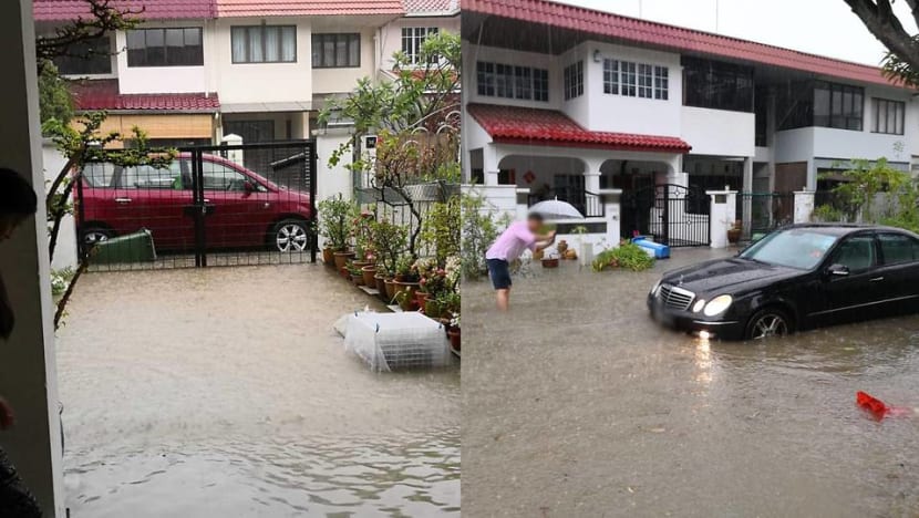
But floods have persisted. Only weeks ago, swathes of Bukit Timah Road and Dunearn Road were filled with murky waters rising high enough to cover car tyres.
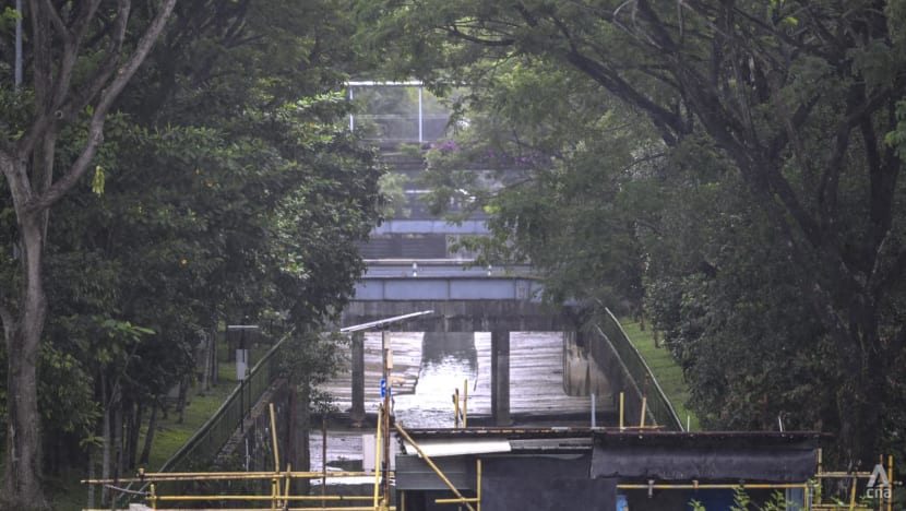
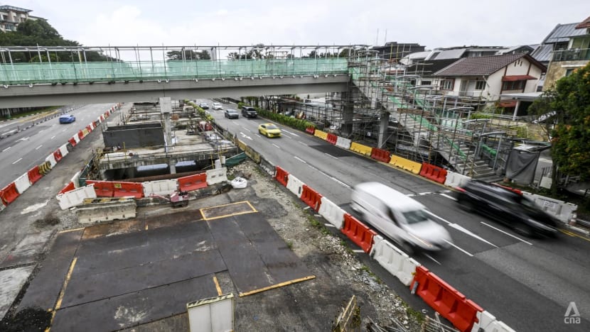
PUB is now working to widen and deepen a 900m-stretch of the main canal - from Rifle Range Road to Jalan Kampong Chantek - to increase its rainwater capacity by 30 per cent.
This was supposed to be completed in 2024, but has been delayed until 2026 to sync with the development of a green corridor.
The project is about 70 per cent complete, PUB senior engineer and project officer Matthew Tan told CNA at a worksite near 913 Bukit Timah Road.
He added that there was insufficient land to further expand the capacity of the main canal. Roads on each side limit how much it can be widened; and the maximum possible depth has already been reached due to underground infrastructure like MRT tunnels.
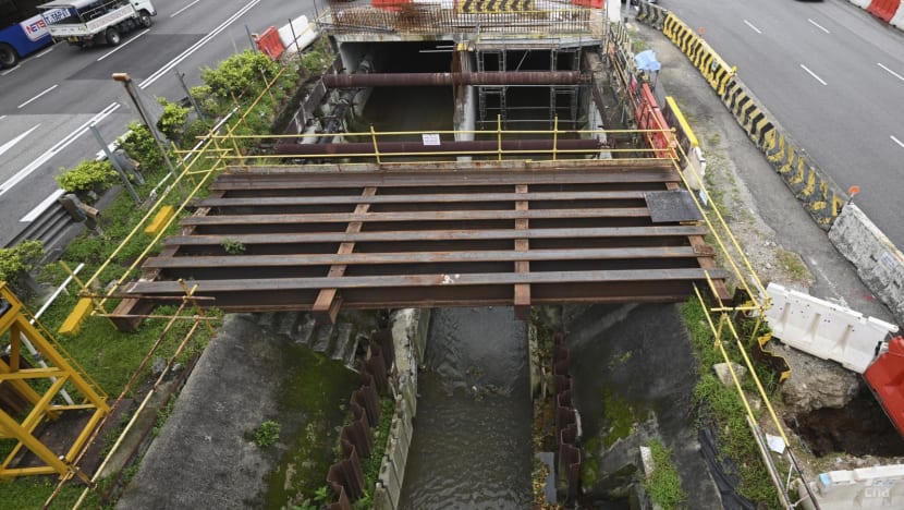
Separately, the team is also upgrading six adjoining culverts - covered drains that can take vehicle loads - that connect to developments from under Bukit Timah Road and Dunearn Road. This will help them smoothly channel water to the main canal.
“At times ... intense rainfall temporarily overwhelms the system,” said Mr Tan.
Increased urbanisation and development has also resulted in more water flowing into the drains, hence upgrades are needed to cater to more runoff, he added.
While not all of Bukit Timah is low-lying, certain pockets - such as the road outside of Coronation Shopping Plaza - are valleys where waters pool. Authorities are still reviewing ways to mitigate flooding in such areas.
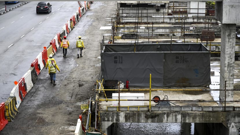
Mr Tan also took CNA through the work involved in upgrading a canal in a busy, populated area.
The team often has to eat into adjacent roads to carry out works, but workers are constrained by the number of lanes they can close due to heavy traffic, especially on Bukit Timah Road. Working within a residential area also limits the number of hours they can be onsite.
Builders also have to contend with existing infrastructure both above- and underground.
For instance, they had to construct an entirely new overhead bridge for pedestrians, just metres away from its original location, when it became clear that the wall of the upgraded canal would come up against a structural support component of the old bridge.
Under the canal, where cables and pipes jostle for space, the team has to coordinate with different agencies to ensure an uninterrupted supply of electricity and gas before they start any demolition works.
Rainy weather itself also impedes efforts, as workers have to evacuate canals when water levels rise.
"We will always make sure that … as a result of our works, we don't cause any flooding," said Mr Tan. "So a lot of that is making sure that the existing connections from the road into the canal are clear and water still flows freely."
WHAT'S BEING DONE AT NEWER DEVELOPMENTS
PUB works with other authorities like the Housing and Development Board (HDB) to parcel out waterways within new housing estates.
Drainage schemes are developed depending on how much land there is to work with; the land topography; and alignment with existing waterways. Topography refers to the terrain and elevation of the land, which give a sense of how water would flow when it rains.
Due to land scarcity, planners also factor in multi-functionality where possible, said PUB engineer Ms Siew.
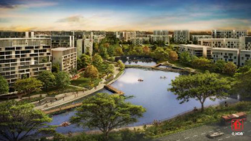
One example is the relatively recent Bidadari estate in central Singapore. The authorities had to account for an increase in stormwater runoff due to the development of the estate.
As certain drains there cannot be widened, authorities had to think of other ways to handle large volumes of rainwater in the event of storms.
They came up with Alkaff Lake in Bidadari Park, which doubles as a recreational spot.
Pedestrians can stroll along footpaths by the lake during dry weather, but these paths will be submerged when the lake fills with stormwater during rain.
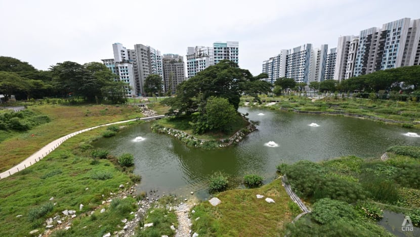
Water running off from half of the estate will be diverted into the 1.8ha lake, as it's the lowest point in the area.
During a storm, the lake can hold four times the amount of water it normally does. Outlet points control the amount of stormwater flowing into a downstream drainage system.
Over at Singapore’s newest town, Tengah, HDB is exploring the possibility of a water body that can similarly manage stormwater.
In June last year, the housing board said this water body, which it referred to as a pond, will temporarily hold stormwater runoff from the southern part of Tengah during storms, thus slowing the discharge of stormwater to public drains.
"For undeveloped sites, there could be more space to create a water body, (it) depends on the opportunities that arise because you have a large greenfield site to work with," said Ms Siew.
PLANNING FOR THE FUTURE
Looming over all these efforts is the spectre of a warming climate and the expectation of heavier rainfall, in turn exacerbating the risk of floods.
“A 1 degree (Celsius) increase in temperature atmosphere has a possibility to store 7.5 per cent more of humidity," NUS' Prof Babovic said.
“So if theoretically, the temperature were to increase by 4 degree Celsius we would get, theoretically, 30 per cent more vapour in the atmosphere. This extra will need to come down in rainfall."
Climate scientist Koh Tieh-Yong however said tropical rain formation was a more complicated process.
“For example, in Singapore, relative humidity is lower when it is hotter during daytime, so the water vapour content of air stays about the same,” said Dr Koh, who co-chairs the World Climate Research Programme’s Asian-Australian Monsoon working group.
“The fact is that different computer models generate rainfall at higher or lower intensity, duration or frequency depending on microphysical details of cloud and rain formation in the tropics. This leads to disparate projections for tropical rainfall.”
Past rainfall statistics have become unreliable for future predictions, Dr Koh added.
“This makes it hard for urban planners to prepare for future floods or dry spells as they need to balance stronger protection against higher costs."
Policymakers across the world have thus settled on deploying affordable protective measures while waiting for research to advance, he said.
In the present day, PUB relies on a rainfall monitoring and prediction system to keep an eye out for flash floods.
This is among measures that guide the agency in its deployment of Quick Response Teams to potential flood areas.
It is also exploring the use of artificial intelligence to enhance these capabilities.
In 2022, water management consultancy Hydroinformatics Institute and telco StarHub announced a pilot collaboration to use the latter’s network of mobile base stations as rainfall sensors. This would provide PUB with an additional source of rainfall intensity.
But further down the line, Singapore will have to turn to increasingly innovative solutions to deal with floods, engineers said.
SIT’s Dr Tay suggested that flood barriers be installed along canals or drains. Under normal conditions, these barriers are deactivated, retracted and "hidden" underground; during flash floods, they can be self- or manually-activated.
“This solution minimises space requirements and reduces the cost of raising canal embankments while keeping the canal accessible to the public, as the barriers remain concealed during normal conditions,” Dr Tay said.
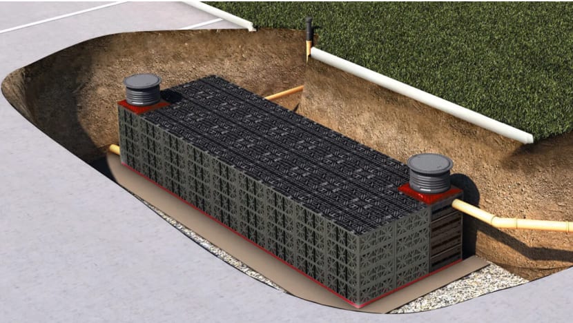
IES' Mr Ng proposed the use of a modular block system that can be built underneath roads, car parks and parks to collect stormwater. Australia and the US currently employ similar models.
Same as a detention tank, this system would temporarily store rainwater during storms for up to four hours, and discharge the water to the nearest public drain after the storm has passed - via a pump or by gravity.
But unlike a detention tank, this modular system would only need to be at least 1m underground, Mr Ng said.
They are made of durable and light materials that can be easily installed after excavation, and can withstand traffic loading, he added.
Prof Babovic meanwhile pointed to nature-based measures to help slow down stormwater flowing into drains. For instance, green roofs - covered with plants - or rain gardens - a depressed area in the ground could absorb, collect and filter rain during storms.
Downstream, research is underway to study the possibility of redistributing stormwater from drains that are filled from a localised storm, to drains outside of the affected area, said Prof Babovic.
“There’s a range of measures that are implemented across the country, not only drains,” he noted. “Over the years, a number of measures have been introduced systematically.
"It’s not something that you can (use) a magic wand and have it fixed overnight. This is years of effort.”
Disclaimer: Investing carries risk. This is not financial advice. The above content should not be regarded as an offer, recommendation, or solicitation on acquiring or disposing of any financial products, any associated discussions, comments, or posts by author or other users should not be considered as such either. It is solely for general information purpose only, which does not consider your own investment objectives, financial situations or needs. TTM assumes no responsibility or warranty for the accuracy and completeness of the information, investors should do their own research and may seek professional advice before investing.
Most Discussed
- 1
- 2
- 3
- 4
- 5
- 6
- 7
- 8
- 9
- 10